The Mardi Himal Trek, introduced in 2012, is a scenic journey through Nepal’s Annapurna region, reaching its highest point at 4200m. Starting in Kathmandu, the trek offers stunning views of the Annapurna Ranges, Mardi Himal, Machhapuchhre, Himchuli, and Tent Peak. The Mardi Himal Trek Map includes an exciting route and memories.
The trek also offers unique cultural experiences with local Gurung and Magar communities, traditional villages, and guesthouses. The journey culminates at Mardi Himal Base Camp.
Introduction to Mardi Himal Trek
The Mardi Himal Trek, located in the Annapurna Range of the Himalayas, is a unique and less crowded trekking experience in Nepal. The route ascends to the base camp of Mardi Himal, offering stunning views of snow-capped peaks, lush valleys.
Unlike popular treks like the Annapurna Circuit or Everest Base Camp, the Mardi Himal Trek is relatively undiscovered. Thus offering tranquility and unspoiled natural beauty. The journey begins in the picturesque village of Kande, followed by a gradual ascent through lush rhododendron forests.
Trekkers can also immerse themselves in the rich culture and hospitality of the local Gurung and Magar communities, witnessing traditional ceremonies and interacting with villagers.
When Is The Best Time to Visit Mardi Himal?
The best time to visit The Mardi Himal is during autumn and spring, offering unique advantages for trekkers. Autumn is the peak season, with stable weather, clear skies, and stunning views of the Annapurna and Dhaulagiri ranges. It coincides with the harvest season, offering opportunities to witness traditional farming practices and interact with local communities.
Spring, from March to May, is characterized by blooming rhododendron forests and mild weather, making it easier to reach Mardi Himal Base Camp. However, the monsoon season should be avoided due to heavy rainfall, leeches, and landslides. The choice of season depends on individual preferences and availability.
Mardi Himal Trek Map for an accurate journey
A map is a crucial tool in outdoor exploration, providing guidance, information, and a blueprint for exploration. It illuminates the path ahead with detailed terrain, landmarks, and key waypoints, ensuring safe and enjoyable journeys.
Beyond navigation, a trekking map provides vital information for trekking preparedness, such as water sources, camping spots, and potential hazards. It also enables trekkers to anticipate challenges, plan routes strategically, and mitigate risks effectively.
A trekking map also fosters a deeper connection with the natural environment. Moreover, fostering an appreciation for the beauty and diversity of the wilderness. It also serves as guardian of safety, equipping trekkers with the knowledge and tools to navigate challenging terrain and obstacles. In remote wilderness areas, a trek map serves as a lifeline, guiding trekkers through adversity and ensuring their well-being.
Key Highlights of Mardi Himal Trek
Scenic Beauty of Mardi Himal’s Landscape
Trekkers are treated to an awe-inspiring panorama of majestic peaks. Among them, the iconic Machhapuchhre (Fishtail), with its distinctive double summit, stands as a sentinel guarding the trail. Alongside, Annapurna South and Hiunchuli rise majestically, their snow-capped peaks glistening in the sunlight.
With each step, the landscape transforms, revealing new vistas that captivate the soul and ignite the imagination. From verdant valleys to rugged ridges, the Mardi Himal Trek is a photographer’s paradise, offering endless opportunities to capture the sublime beauty of the Himalayas in all its glory.
Glimpse Into The Rich Nepalese Cultural
The Mardi Himal Trek offers a rare glimpse into the rich Nepalese culture and tradition. Along the trail, trekkers encounter remote villages inhabited by ethnic Gurung and Magar communities, whose warm hospitality and vibrant culture leave an indelible mark on the journey.
From traditional stone houses adorned with prayer flags to ancient monasteries perched on rocky cliffs. Each village tells a story of resilience and harmony with nature. Trekkers have the opportunity to immerse themselves in the daily lives of the locals, participating in age-old customs and rituals that have endured for generations.
Whether sharing a meal with a local family or joining in a traditional dance performance. The cultural immersion adds depth and authenticity to the trekking experience, forging connections that transcend language and borders.
Thrilling World Of Wildlife Encounters
Among the dense forests and alpine meadows, elusive creatures such as the Himalayan Thar and deer roam freely. Their graceful movements identify the delicate balance of nature. Meanwhile, the air is alive with the melodious chirping of various bird species, from colorful pheasants to majestic eagles soaring overhead.
A well-prepared trek map serves as a guide to potential wildlife sighting areas. Also, heightens the thrill of the journey as trekkers keep a keen eye out for these elusive creatures. Each encounter with wildlife is a reminder of the interconnectedness of all living beings and the importance of preserving the natural habitat for future generations to enjoy.
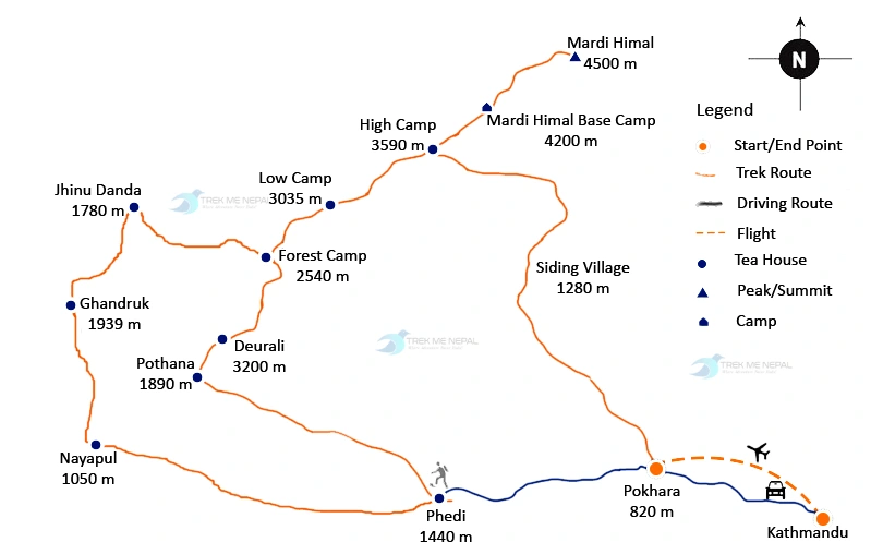
Route Planning Map Of Mardi Himal
Before setting foot on the trail, it’s essential to familiarize yourself with the Mardi Himal Trek map. While the route is relatively straightforward, having a clear understanding of the trail can enhance your overall experience and ensure a smooth trekking adventure.
The Mardi Himal Trek typically begins from the lakeside city of Pokhara, where adventurers embark on a scenic drive to the starting point at Kande or Phedi. From there, the trail winds through picturesque villages, terraced farmlands, and rhododendron forests gradually gaining elevation as you ascend toward the majestic Mardi Himal Base Camp.
A detailed map of the Mardi Himal Trek will highlight key landmarks along the route, including popular stopping points such as Pothana, Forest Camp, Low Camp, High Camp, and ultimately, Mardi Himal Base Camp itself.
Additionally, the map will outline alternative routes, side trails, and points of interest, allowing trekkers to customize their journey according to their preferences and time constraints.
While the Mardi Himal Trek is generally well-marked, carrying a reliable map or GPS device is recommended to navigate any potential detours or changes in the trail due to weather conditions or other factors.
Navigating Altitude on the Mardi Himal Trek
Altitude is a crucial factor to consider when undertaking any trekking adventure, and the Mardi Himal Trek is no exception. While not as demanding as some of the higher-altitude treks in the region, such as the Annapurna Circuit or Everest Base Camp Trek, trekkers should still be mindful of the elevation gain along the route.
The highest point on the Mardi Himal Trek is Mardi Himal Base Camp, situated at an altitude of approximately 4,500 meters (14,764 feet) above sea level. While this altitude is considered moderate by Himalayan standards, trekkers need to acclimatize properly to minimize the risk of altitude-related illnesses such as altitude sickness.
To acclimatize effectively, it’s recommended to ascend gradually, take rest days as needed, and stay hydrated throughout the trek. Adequate rest, proper nutrition, and listening to your body are key components of a successful trekking experience at high altitudes.
Furthermore, being aware of altitude-related symptoms such as headaches, nausea, dizziness, and fatigue is essential. If experiencing any severe symptoms, it’s crucial to descend to a lower altitude and seek medical attention if necessary.
Conclusion
In conclusion, understanding the Mardi Himal Trek map and altitude is essential for a safe and enjoyable trekking experience in the Annapurna region of Nepal. Trek Me Nepal, with its expertise and knowledge of the region, provides valuable resources and support for trekkers planning to embark on this unforgettable journey.
By familiarizing themselves with the route, landmarks, and elevation gain, trekkers can navigate the trail with confidence, maximizing their enjoyment of the breathtaking scenery and cultural encounters along the way. Additionally, being mindful of altitude-related challenges and acclimatization techniques is crucial for ensuring a successful trekking adventure. With proper preparation and a sense of adventure, the Mardi Himal Trek promises to be a rewarding experience, offering trekkers the opportunity to create lasting memories amidst the pristine beauty of the Himalayas.
FAQs
What is the difficulty level of the Mardi Himal Trek in terms of altitude?
The Mardi Himal Trek is considered to be of moderate difficulty in terms of altitude. While the highest point, Mardi Himal Base Camp reaches an altitude of approximately 4,500 meters (14,764 feet), the overall elevation gain is gradual. However, trekkers should still be prepared for altitude-related challenges and acclimatization is essential.
Do I need a guide to navigate the Mardi Himal Trek map?
While the Mardi Himal Trek is generally well-marked, having a guide can be beneficial, especially for first-time trekkers or those unfamiliar with the region. Guides provide valuable insights into the trail, and local culture, and can assist with navigation, ensuring a smoother and more enriching trekking experience.
Are there alternative routes or side trails along the Mardi Himal Trek?
Yes, there are alternative routes and side trails that can be explored during the Mardi Himal Trek. These routes may offer different perspectives of the landscape, cultural encounters, or additional attractions such as viewpoints or waterfalls. Consulting a detailed map or local guide can help identify these alternative routes.
What should I do to prepare for altitude on the Mardi Himal Trek?
To prepare for altitude on the Mardi Himal Trek, it’s important to gradually acclimatize by ascending slowly, staying hydrated, and taking regular rest days. Prior physical conditioning and maintaining a healthy lifestyle can also help improve overall fitness and reduce the risk of altitude-related illnesses.
How can I obtain a reliable map for the Mardi Himal Trek?
Reliable maps for the Mardi Himal Trek are available for purchase in outdoor gear shops in Pokhara or Kathmandu. Additionally, trekking agencies or tour operators such as Trek Me Nepal often provide maps as part of their trekking packages. It’s essential to choose a map that is up-to-date and includes key landmarks, trails, and elevation details.
What are the risks associated with altitude sickness during the Mardi Himal Trek?
Altitude sickness, also known as acute mountain sickness (AMS), can occur when ascending to high altitudes too quickly without proper acclimatization. Symptoms may include headaches, nausea, dizziness, and fatigue. In severe cases, altitude sickness can lead to more serious conditions such as high altitude pulmonary edema (HAPE) or high altitude cerebral edema (HACE). It’s important to recognize symptoms early and descend to lower altitudes if necessary.
Comment (0)