


Who We Are
Guide of the Year
Documents
Charity & SR
Latest Posts
Questions & Answers
")
Most people picture Nepal as emerald forests, terraced hillsides, and the white giants of the Himalaya. Upper Mustang is none of that. Upper Mustang is not like the green, forested parts of Nepal. It is dry, open, and filled with red cliffs and wide valleys.
The landscape looks more like a desert. You can find very old monasteries, caves in the hills, and a historic walled town where people still follow traditional ways of life. The culture is closer to Tibetan traditions than to other parts of Nepal.
Many people are surprised when they arrive. The space, silence, and strong winds make the place feel very different. As you spend more time there, the experience often becomes calm and meaningful.
This guide will help you understand what Upper Mustang is like, why people visit, how permits work, the trekking routes, and useful tips to prepare. It is designed for both beginners and experienced trekkers who want a clear idea before planning their trip.
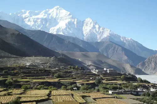
Upper Mustang is the northern section of the Mustang district in Nepal's Gandaki Province, nestled deep in the Himalayas along the border with Tibet. It sits in the upper valley of the Kali Gandaki River, one of the deepest gorges on Earth, and stretches northward to the Tibetan plateau.
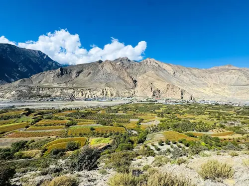
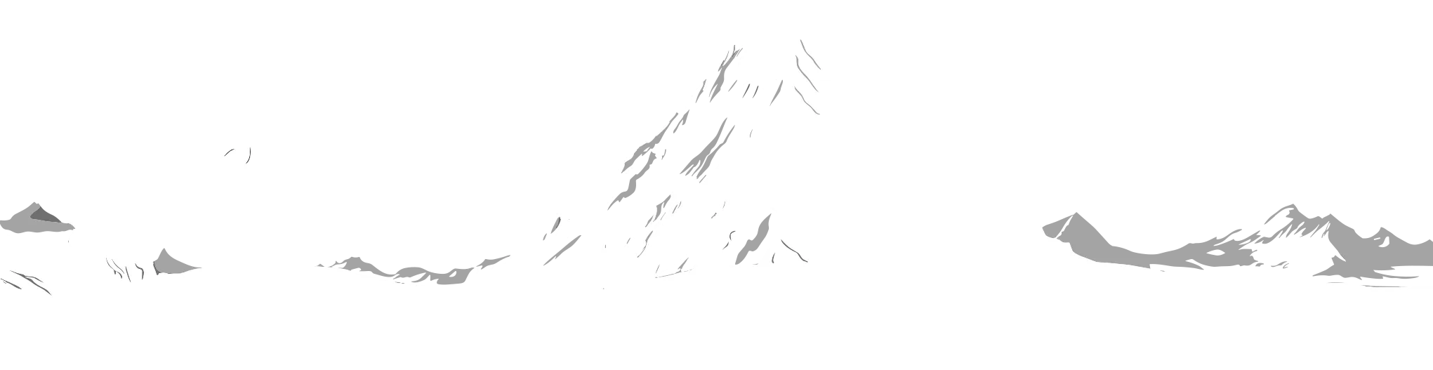
Geographically, Upper Mustang lies in the rain shadow of the Annapurna and Dhaulagiri ranges. The monsoon clouds drop their rain on the southern slopes before reaching here, producing a high-altitude desert that is dry, wind-carved, and dramatically beautiful. The landscape is a patchwork of ochre, rust, and grey: eroded canyons, rainbow-streaked cliffs, and flat-topped mesas that glow amber at sunset.
Culturally, Upper Mustang is one of the most intact pockets of traditional Tibetan Buddhist civilisation left on earth. While modern development has dramatically changed much of Tibet itself, Mustang's relative isolation preserved its ancient monasteries, traditions, rituals, and language almost completely. Walking through its villages feels like stepping back five centuries.
The region is also known as the Kingdom of Lo. Until 2008, Upper Mustang was an actual semi-autonomous kingdom with its own king, Raja Jigme Palbar Bista, who ruled from the walled capital of Lo Manthang. The last king sadly passed away in 2016, but his legacy lives on in the culture, architecture, and deep reverence the local Loba people hold for their royal heritage.
Upper Mustang's most defining qualities include its stark desert landscape, the perfectly preserved medieval city of Lo Manthang, ancient sky caves carved into sheer cliff faces, the Tiji Festival (one of Asia's most dramatic Buddhist ceremonies), and a living Tibetan culture untouched by mass tourism.
Lower Mustang covers the area south of Kagbeni, including Jomsom, Marpha, and Muktinath. It is open to all trekkers without a special permit and forms part of the Annapurna Circuit. Upper Mustang begins at Kagbeni and extends north to Lo Manthang and the Tibetan border. This is the restricted zone, far more remote, far less visited, and culturally far richer. To enter, you need a Restricted Area Permit.
After China took control of Tibet in 1950, Upper Mustang became a refuge for Tibetan resistance fighters who used its remote valleys for guerrilla operations through the 1960s and early 1970s. Nepal eventually closed the region entirely to foreigners in 1974. For eighteen years, almost no outsider entered.
Nepal reopened Upper Mustang to foreign trekkers in 1992, but with strict conditions: organised groups only, licensed guides mandatory, and an expensive special permit. The Forbidden Kingdom label has stuck because it accurately describes what this place was for so long and what it still feels like when you finally arrive.
Yes, and possibly more so now than ever before. A road now connects Jomsom to Lo Manthang, which has changed some sections of the classic trekking experience. But the eastern route through Drakmar, Ghiling, and the high plateau remains spectacularly raw and road-free.
The culture of Lo Manthang is as rich as it has ever been. The cave monasteries are still there, still ancient, still barely visited. And in 2026, the permit fee dropped significantly from a flat $500 to $50 per day, making the region more accessible than it has been in decades.
Lo Manthang is the destination that draws most trekkers north. A walled city sitting on a flat plateau at around 3,800 metres, it is surrounded by stark brown hills and punctuated by the bright reds and whites of monastery walls.
The city walls enclose a maze of narrow whitewashed alleys, mud-brick homes stacked against each other, prayer wheels spinning in long rows, and rooftop terraces where locals dry apples and barley. It is not a museum but a living, breathing community where families go about their daily lives much as they have for five centuries.
Inside Lo Manthang, three major monasteries are the centrepieces.
Jampa Gompa, built in the 15th century, contains a magnificent three-storey clay statue of the Future Buddha, Maitreya, and its walls are lined with ancient thangka paintings now being carefully restored with support from international conservation efforts.
Thupchen Monastery is arguably the most impressive structurally, a large barnlike assembly hall whose crumbling ceiling frescoes were the focus of a major American-Nepali restoration project. The restored murals are stunning in the slanted morning light; visit early when the colours truly come alive.
Chode Monastery is the active religious heart of the community, where monks conduct daily prayers. It is the smallest of the three but the most alive. You can often hear chanting from the street outside, a sound that carries across the walled city in the thin mountain air and stays with you long after you have left.
Beyond the monasteries, spend time simply walking the alleys of Lo Manthang. Peek into courtyards. Buy local apple brandy or dried apricots from families who sell them from their doorways.
Notice the intricately carved wooden window frames, the painted chortens at every entrance, and the rooftop altars with their offerings of juniper smoke. This is what makes Lo Manthang special: not just its extraordinary age, but its warmth and its unbroken continuity with the past.
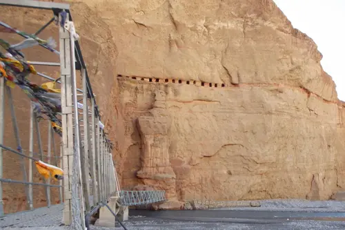
Thousands of human-made caves are cut into the cliff faces throughout the region: some near ground level, others perched impossibly high in vertical rock walls hundreds of metres above the valley floor. These caves served as burial chambers, meditation retreats, and emergency shelters across different eras.
The most visited cave complexes are Chhoser Cave, a multi-level complex carved into a massive ochre cliff face north of Lo Manthang, and Chungsi Cave, associated with the great sage Guru Rinpoche and an active pilgrimage site for local Loba people.
Ghar Gompa is considered one of the oldest monasteries in Nepal; some scholars date it to the 8th century. It sits alone on a hillside above the village of Dhee, and the walk to it along the Mui La route is one of the most scenic days of the entire trek.
Luri Gompa, hidden in a side canyon north of Lo Manthang near the village of Yara, requires a half-day detour but rewards you with a cave monastery containing some of the finest 14th-century Buddhist murals in the entire Himalayan region. Very few trekkers make the effort, which means you may well have it entirely to yourself.
The Tiji Festival is a three-day Buddhist ceremony held in Lo Manthang each spring, typically in late April or May. It celebrates the victory of the deity Dorje Jono over a demon threatening the Kingdom of Lo with drought and destruction.
Over three days, monks perform elaborate masked dances in the open square outside the city walls, dressed in vivid brocade costumes and painted wooden masks. The entire community attends: elders in traditional dress, children perched on rooftops, and a growing number of photographers and travellers.
If you can time your trek to coincide with Tiji, do it. Book well in advance, as accommodation in Lo Manthang during Tiji fills up a year or more ahead.
The landscape of Upper Mustang is not what most people expect from Nepal. There are no jungle-covered ridges, no rhododendron forests, no waterfalls. Instead, the terrain is high-altitude desert: wide, dry, windswept, and extraordinarily colourful. Cliff walls layered in red, ochre, grey, white, and even blue and green glow amber at sunset.
The effect, especially in afternoon light, is something between the American Southwest and the surface of another planet. The Kali Gandaki River flows through the centre of the valley, and its gorge between Dhaulagiri and Annapurna is technically the world's deepest gorge when measured from peak to river.
Even in Upper Mustang, where the valley widens, the scale of the surrounding landscape is immense and humbling. Afternoons in the valley are typically very windy, which is why starting early each morning is strongly advised and why reaching your destination before early afternoon becomes a satisfying daily goal.
The Government of Nepal has revised the Upper Mustang Restricted Area Permit (RAP) system, replacing the old fixed pricing model with a more flexible structure.
Previously, trekkers were required to pay USD $500 per person for 10 days, regardless of how long they stayed. This made shorter trips unnecessarily expensive.
New Permit Structure (2026)
USD $50 per person, per day
No minimum stay requirement
Pay only for the actual number of days spent inside Upper Mustang
Cost Examples
5-day trip → $250
10-day trek → $500
14-day itinerary → $700
Note: This update makes short treks and flexible itineraries much more practical, while maintaining restricted access.
Category | Details |
Region | Upper Mustang (Restricted Area of Nepal) |
Main Permit | Restricted Area Permit (RAP) |
Permit Cost | USD $50 per person, per day |
Old System (Pre-2025) | USD $500 flat for 10 days |
Minimum Stay | None (pay per actual days) |
Example Cost (5 days) | $250 |
Example Cost (10 days) | $500 |
Example Cost (14 days) | $700 |
Application Method | Through registered trekking agency only |
Independent Application | Not allowed |
Group Requirement | Minimum 2 trekkers required |
Guide Requirement | Licensed Nepali guide mandatory |
Permit Issued In | Kathmandu and Pokhara only |
Processing Time | 3–7 working days |
Additional Permit | ACAP (Annapurna Conservation Area Permit) |
ACAP Cost | ~NPR 3,000 (~USD $22) |
ACAP Validity | No time limit |
TIMS Requirement | Not required if flying; required if traveling by road (~$20) |
Restricted Status | Yes (strict regulations remain) |
Solo Trekking | Not allowed |
Compliance Requirement | Must carry permits at all checkpoints |
Penalty for Violation | Fines, deportation, or travel restrictions |
Upper Mustang's position in the Himalayan rain shadow makes it one of Nepal's most seasonally flexible trekking destinations. While most of Nepal is inaccessible during the June to August monsoon, Upper Mustang remains relatively dry and trekable year-round.
The most popular season. Temperatures are mild, skies are generally clear, and the Tiji Festival falls in late April or May. March and early April are slightly quieter and equally beautiful. Afternoon winds pick up from April onward, which is manageable but worth factoring into your daily schedule.
Upper Mustang's geography is a genuine advantage here. The Annapurna and Dhaulagiri massifs block monsoon clouds from the south, leaving the northern valleys in a dry zone. Trekking in this season means dramatically fewer visitors and a surprisingly green lower valley.
The main downside is frequent flight delays or cancellations between Pokhara and Jomsom due to cloud cover. August also hosts the Yartung Festival, a traditional horse-racing celebration in villages including Tsarang and Muktinath.
Rivals spring as the best overall season. The monsoon ends in September, leaving extraordinary visibility and stable temperatures. October is considered by many experienced trekkers to be the single best month of the year for Upper Mustang: crystal-clear skies, stable temperatures, lower winds than spring, and golden fields of harvested barley. November is quieter and colder, with nights below freezing near Lo Manthang, but still very manageable for a well-equipped trekker.
The least-visited season demands the most preparation. Temperatures at Lo Manthang can drop to -20°C at night in January, and some high passes on the eastern loop may be blocked by snow.
Daytime conditions can still be surprisingly pleasant on a sunny day, and the trails offer near-total solitude. The Losar (Tibetan New Year) festival in February is a rich, intimate cultural experience in Lo Manthang's monasteries.
Most trekkers fly into Jomsom from Pokhara, trek to Kagbeni on day one, register permits at the checkpoint, and proceed north through Chele, Samar, Shyangboche, Ghiling, Ghami, and Charang before arriving at Lo Manthang on approximately day five.
The western route is the most developed. A road now runs along much of this corridor, meaning some sections involve walking alongside a gravel track. The scenery remains extraordinary: dramatic canyons, ancient villages, and the Himalayan backdrop. But the classic undisturbed trail experience is better found on the eastern return.
The eastern route from Lo Manthang through Drakmar, Dhee, Ghiling, and down through Muktinath is where the road has not yet arrived. This route passes through wilder, higher terrain with longer distances between villages.
The views back toward Tibet, the silence of the high plateau, and the dramatically coloured landscape of Drakmar (meaning "red rock") are among the most vivid memories trekkers take home.
Our preferred approach at Trek Me Nepal is to cover the western route by jeep and trek the eastern loop on the return, giving you the best of both worlds.
Day | Route | Altitude | Walk Time |
Day 1 | Fly Pokhara–Jomsom, trek to Kagbeni | 2,800 m | 3 hrs |
Day 2 | Kagbeni to Chele | 3,050 m | 5–6 hrs |
Day 3 | Chele to Samar | 3,660 m | 5 hrs |
Day 4 | Samar to Ghiling via Nyi La pass | 3,800 m | 5–6 hrs |
Day 5 | Ghiling to Ghami | 3,520 m | 4 hrs |
Day 6 | Ghami to Tsarang (Charang) | 3,560 m | 4–5 hrs |
Day 7 | Tsarang to Lo Manthang | 3,840 m | 4–5 hrs |
Day 8 | Explore Lo Manthang and excursion | 3,840 m | Full day |
Day 9 | Lo Manthang to Ghiling (east route via Drakmar) | 3,800 m | 6–7 hrs |
Day 10 | Ghiling to Kagbeni / Jomsom | 2,720 m | 5–6 hrs |
The 10-day route is the minimum to do Upper Mustang justice. Extra days allow you to visit Luri Gompa from Yara (add 2 days), explore Chhoser Cave north of Lo Manthang, spend more time in Lo Manthang itself, or trek the Mui La route past Ghar Gompa on the return. A 14-day itinerary is our most-booked option at Trek Me Nepal.
Key villages on the trail:
Kagbeni is the gateway, a medieval-feeling village at the confluence of the Kali Gandaki and Jhong Khola rivers. Samar is the first major village inside Upper Mustang, surrounded by juniper forests.
Ghiling sits below red sandstone cliffs with one of the most photogenic monasteries on the route. Tsarang has a large red dzong perched on a promontory above the village. Yara is the jumping-off point for the Luri Gompa side trip.
The Upper Mustang trek is generally rated moderate in difficulty, harder than a gentle valley walk but significantly easier than a technical high-altitude trek like Everest Base Camp or Manaslu Circuit Trek.
Elevation is the main challenge. You spend most of the trek between 2,800 and 3,900 metres above sea level, with occasional passes reaching just above 4,000 metres. This is high enough for altitude sickness to be a real concern, especially for trekkers arriving from low altitudes without proper acclimatisation.
There is no technical climbing, no fixed ropes, and no glacier crossings. Anyone comfortable walking 5 to 7 hours per day on uneven terrain can complete the standard 10-day itinerary.
Jomsom (starting point): 2,720 m
Kagbeni (restricted zone entry): 2,800 m
Nyi La pass (highest point on western route): 4,010 m
Lo Manthang: 3,840 m
Eastern loop high point: 3,950 m
Ascend gradually; the standard itinerary is designed with this in mind. Drink 3 to 4 litres of water per day, as the dry and dusty air of Upper Mustang accelerates dehydration more than most trekkers expect.
Rest on arrival at each new altitude and avoid physical exertion on your first afternoon at a higher camp. Sleep at lower elevations whenever possible, following the principle of climb high, sleep low.
Avoid alcohol and sedatives in the first few days at altitude. Carry Diamox (acetazolamide) if your doctor advises it, as this prescription medication helps many trekkers acclimatise more effectively.
Know the signs of serious altitude sickness: persistent headache unresponsive to paracetamol and rest, loss of coordination, confusion, or breathlessness at rest. If any of these occur, descend immediately and seek medical attention. Never ignore these symptoms in the hope they will pass on their own.
Our guides at Trek Me Nepal are trained in altitude sickness recognition and response, and they carry first aid equipment on every trek.
Most trekkers fly from Kathmandu to Pokhara, a 25-minute domestic flight one-way. From Pokhara, the Jomsom flight takes 20 to 25 minutes through the Kali Gandaki gorge between the walls of Dhaulagiri and Annapurna, offering some of the most breathtaking aerial views on earth.
This flight operates under visual flight rules and cannot run in poor visibility, so cancellations are common. Always build a buffer day into your itinerary on both ends. The alternative is a 5-6-hour jeep drive from Pokhara to Jomsom along the Mustang Road.
With the road now connecting Jomsom to Lo Manthang, the Upper Mustang jeep tour has become a popular option, particularly among families or those with limited time. A jeep tour covers the ground faster (2 to 3 days to reach Lo Manthang by road versus 5 to 6 days on foot) but misses the gradual immersion of trekking.
Our honest recommendation: if you have 10 or more days, trek. If you have 4 to 5 days or physical limitations, a jeep tour still gives you access to Lo Manthang and the major cultural sites. A hybrid approach, jeeping some sections and trekking others, is what many of our clients choose and is often the most practical solution for shorter itineraries.
Helicopter tours depart Pokhara or Jomsom, land at Lo Manthang for a few hours, and return the same day. For those who cannot trek due to physical constraints or who have very limited time, it is a viable option.
Basic to mid-range accommodation is available in all major villages on the standard route: Kagbeni, Chele, Samar, Ghiling, Ghami, Tsarang, and Lo Manthang. Most teahouses offer simple twin or double rooms with foam mattresses and thick blankets, attached or shared bathrooms with hot water via gas heaters, a wood-burning stove dining room, and solar-powered charging facilities.
In Lo Manthang, several guesthouses have been upgraded and offer more comfortable rooms and varied menus. Prices remain very reasonable per room per night. Homestays are also available in several villages and are warmly recommended for an authentic cultural experience.
Dal bhat is the most reliable and filling meal on the trail, available everywhere and usually served in unlimited portions. After a long day of walking at altitude, there is nothing quite like a heaping plate of lentil soup, rice, seasonal vegetables, and pickle to restore energy and warmth.
Tibetan-influenced dishes are a distinctive feature of Upper Mustang that you will not find as commonly elsewhere in Nepal: tsampa (roasted barley flour mixed into a thick paste with butter tea or water, the staple food of the Loba people), thukpa (Tibetan noodle soup, warming and hearty), momo (steamed or fried dumplings filled with vegetable or yak meat), and chang (local barley beer, mild and slightly sour, drunk from wooden bowls).
Most teahouses also offer pasta, eggs, pancakes, and fried rice for those wanting more familiar options. Vegetable and meat choices are limited compared to cities, and menus repeat themselves after a few days, but the flavours are honest and the portions generous. Drink only bottled, boiled, or purified water throughout the trek, and carry your own purification tablets or filter to reduce plastic waste.
Electricity is available in most teahouses via solar panels. NTC (Nepal Telecom) has the widest mobile coverage in Upper Mustang. WiFi is available in some lodges in Lo Manthang, but unreliable. Medical facilities are extremely limited inside Upper Mustang.
The nearest proper hospital is in Jomsom. Carry a comprehensive first aid kit and ensure you have travel insurance that covers helicopter evacuation. There are no ATMs in Upper Mustang. Carry all the cash you will need in Nepali rupees before leaving Jomsom.
Temperatures in Upper Mustang can swing from -10°C at night near Lo Manthang to 20°C in a sheltered sunny spot at midday. The layering system is essential.
Base layer: Moisture-wicking thermal underwear, top and bottom. Merino wool is ideal.
Mid layer: A warm fleece or down jacket. This is your primary insulation piece.
Outer layer: A windproof and waterproof shell jacket. The Kali Gandaki valley winds are legendary.
Trekking trousers: Convertible trousers with one warm pair for evenings.
Thermal hat, sun hat, buff, and gloves: All essential against fierce sun, wind, and dust.
Face mask or buff: dust from road sections and wind is a genuine issue
Quality sunglasses with UV protection: altitude radiation is intense
Trekking poles: strongly recommended for long descents on the eastern loop
Sleeping bag liner: adds warmth and hygiene over a long trip
Headlamp with spare batteries
Water purification filter or tablets
Sunscreen (SPF 50+) and lip balm: reapply frequently
Basic first aid: blister kit, paracetamol, ibuprofen, rehydration sachets, antiseptic, Diamox if prescribed
Cash in Nepali rupees: plan generously, there are no ATMs past Jomsom
Upper Mustang is one of the most photographically rewarding places in Asia. Dust protection is critical: use a camera bag with good seals and change lenses in sheltered spots. The ochre and red cliffs glow most beautifully in the hour after sunrise and before sunset. Always ask before photographing people, particularly during religious ceremonies.
Upper Mustang does not reveal itself all at once. It gives itself slowly, over days of walking through its canyon landscapes and sitting in its monastery courtyards and eating meals in its teahouses while the wind rattles the prayer flags on the rooftop.
By the time most trekkers reach Lo Manthang, they have already understood something they cannot quite put into words. The place has a quality of stillness, of deep time, that very few places on earth still possess. The medieval city feels genuinely medieval.
The monks praying in Chode Monastery are continuing a tradition that has not been interrupted for centuries. The cave dwellings in the cliffs above the valley were carved by human hands two thousand years ago.
When you sit on the rooftop of your guesthouse in Lo Manthang as the sun sets behind the Tibetan plateau and the sky turns from orange to violet over the canyon walls, the weight of all that history is something you feel rather than think.
We have guided hundreds of people through Upper Mustang over the years, and we have never met anyone who wished they had not gone. The only consistent regret people express is not staying longer.
If you are ready to start planning, we would love to help. Whether you have 10 days or 14, a tight budget or a preference for more comfort, a solo traveller needing a partner or a group of friends ready to go, we can build an Upper Mustang experience that fits your situation precisely.
Contact Trek Me Nepal to begin planning your trip. We will take care of permits, logistics, guides, and every detail in between, so that all you need to focus on is being present in one of the most extraordinary places on earth.
No. Solo trekking in Upper Mustang is prohibited. You must be part of a group of at least two people and must be accompanied by a licensed Nepali guide employed through a registered trekking agency.
Independent travellers who want to go alone can approach agencies to connect them with another solo traveller for the permit application, which is common and straightforward.
Yes. Despite the permit fee reduction in November 2025, Upper Mustang remains a designated Restricted Area. The RAP permit is still mandatory for all foreign nationals.
The 2026 change was purely about pricing, not about relaxing access controls. Nepal maintains restricted status to protect the region's cultural heritage, sensitive ecosystem, and security near the Tibetan border.
Strikingly so. Many travellers who have visited both regions say that Upper Mustang preserves traditional Tibetan Buddhist culture more authentically than much of modern Tibet, where decades of development and policy have significantly altered the traditional way of life.
The Loba people are ethnically and culturally Tibetan: they speak a dialect of Tibetan, practice Tibetan Buddhism, and maintain the ancient rituals and monastery traditions of their ancestors.
If you have ever wanted to experience traditional Tibetan culture in a setting unaffected by modern political pressures, Upper Mustang is the closest thing available.
Both are restricted-area treks in western Nepal offering profound cultural immersion. Upper Mustang is more accessible: simpler permits, lower altitudes (maximum around 4,000 m versus Dolpo's passes above 5,000 m), existing teahouse infrastructure, and a road into Lo Manthang.
Dolpo is a more serious undertaking with higher passes, longer distances between villages, camping often required, and much more logistical complexity.
For most trekkers wanting a transformative experience without committing to a full expedition, Upper Mustang is the better starting point. Dolpo is where you go next.
Yes, when approached with proper preparation. Altitude is the most significant risk; follow the acclimatisation advice and never push through serious altitude sickness symptoms. Afternoon winds can be severe, so plan your days to be on the trail in the morning.
The remoteness demands comprehensive travel insurance with helicopter evacuation cover. On the eastern loop route, trails are less well-marked and a guide is invaluable.
The permit and guide system, which can feel bureaucratic from outside, actually contributes meaningfully to safety: authorities know who is in the region, where they are, and when they are expected to return.
No. As of 2026, the Korala border crossing at the northern end of Upper Mustang remains closed to foreign trekkers. You cannot cross into Tibet as a tourist.
The proximity to Tibet is felt everywhere in the culture, architecture, and religious practice, and you can see Tibet from certain high viewpoints. But the legal boundary is clear and firmly controlled.
Check out recent travel trends and news by Trek me Nepal


More Reasons Why Travellers Trust Us


Bipin Thapa Magar
Guide of the Year | Operations Manager & Chief Planner | Trek Me NepalBipin Thapa Magar is a highly experienced trekking and expedition professional with over 20 years in Nepal’s adventure tourism industry. He began his journey in 2004 as a porter and gradually advanced... Read More