


Who We Are
Guide of the Year
Documents
Charity & SR
Latest Posts
Questions & Answers

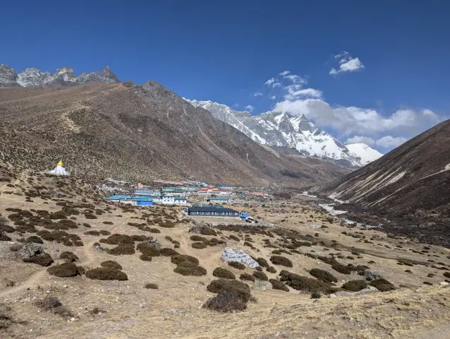
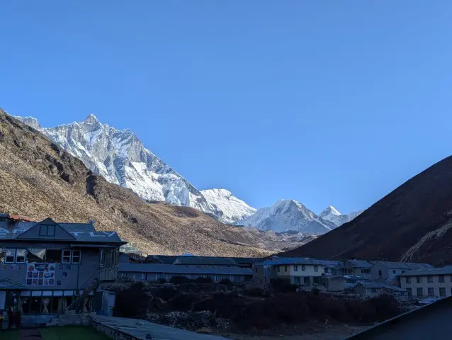
Dingboche is a high-altitude Sherpa village in Nepal’s Khumbu region, situated at 4,410 meters (14,470 feet) above sea level. Located in the Imja Valley, it is a crucial acclimatization stop for trekkers on their way to Everest Base Camp (EBC).
The village is surrounded by towering Himalayan peaks, including Ama Dablam, Lhotse and Island Peak, and visitors get the most stunning views of the mountain in the region.
Dingboche lies in the Solukhumbu District of northeastern Nepal, in Koshi Province and within Sagarmatha National Park, a UNESCO World Heritage Site. It lies along the popular trekking route from Namche Bazaar to Everest Base Camp.
Dingboche is a mandatory acclimatization point for trekkers heading to Everest Base Camp. At this altitude, the body needs time to adjust to thinner oxygen levels, and skipping proper acclimatization increases the risk of altitude sickness (AMS). Most trekkers spend 1 to 2 nights here, using the time for short hikes to higher elevations before descending to sleep to help the body adapt safely.
Dingboche is a popular among trekkers because it is an acclimatization Hub as its elevation makes it ideal for adjusting before ascending to higher camps like Lobuche or Gorak Shep. It is a scenic rest stop and is less windy than other villages in the region. It is a junction for routes to EBC, Island Peak, and the Imja Valley.
Particulars | Details |
Location | Imja Valley, Khumbu Region, Solukhumbu District, Nepal. Coordinates: 27°53′N, 86°49′E |
Elevation | 4,410 meters (14,470 feet) |
Population | ~200 (seasonal fluctuations due to tourism) |
Time Zone | UTC+5:45 (Nepal Standard Time) |
Postal Code | 56002 (shared with nearby villages) |
Acclimatization Importance | Mandatory stop for acclimatization on the Everest Base Camp trek. Spend 1-2 nights to reduce AMS risk. |
Nearby Routes | EBC, Island Peak, Imja Valley, Lobuche, Pheriche |
Weather | Spring (0°C to 6°C, -24°C to -13°C); Summer (9°C to 12°C, -5°C to -1°C); Autumn (1°C to 10°C, -23°C to -6°C); Winter (-5°C to -1°C, -30°C to -27°C) |
Key Attractions | Dingboche Monastery, Imja River Walk, Nangkartshang Peak hike, Panoramic Mountain Views of Ama Dablam, Lhotse, Lobuche ,Island Peak, cultural landmarks. |
Accommodation | Basic lodges/teahouses (e.g., Hotel Good Luck, Summit 4410m, Peaceful Lodge). |
Food | Dal Bhat, garlic soup, Sherpa stew, momos, apple pie. Vegetarian dishes are safer. |
Altitude Sickness Prevention | Hydrate (4-5 liters/day), avoid alcohol, eat carbs, consider Diamox. Early AMS symptoms require rest & hydration. |
Emergency Help | Nearest hospital: Himalayan Rescue Association Clinic (Pheriche, 2 hrs). Emergency helicopter rescue available. |
Cultural Tradition | Tradition like Ding where Locals leave the village from mid-July to mid-August for animal's well-being. |
Acclimatization Tips | Follow the "climb high, sleep low" principle; use trekking poles; avoid rapid ascents. |
The village is home to around 200 people, primarily Sherpas who rely on tourism, farming, and yak herding. As residents of most villages in the Khumbu region, the locals of Dingboche have a primarily Buddhist influence. Traditional farming are still utilised by the locals growing barley and potatoes here.
Family-run guesthouses provide meals and lodging to visitors, often decorated with Tibetan Buddhist art. Dingboche’s mix of natural beauty, trekking necessity, and cultural authenticity makes it one of the most memorable stops on the Everest trail.
As per the 2011 Nepal Census, Dingboche had an estimated population of approximately 200 permanent residents. The village follows a seasonal fluctuation in population due to tourism. In peak trekking seasons (Spring and Autumn) there is a slight increase in residents as temporary workers, guides, and lodge staff increase in numbers.
However in off-season like in Winter (December to February), many locals migrate to lower altitudes, leaving a smaller community residing in the village.
Latitude: 27°53′N
Longitude: 86°49′E
Topographic Context:
Located in the Imja Khola Valley, flanked by:
North: Nangkartshang Peak (5,083m)
South: Ama Dablam (6,812m)
GPS Landmarks:
1.5 km west of the Imja River.
8.4 km northeast of Lobuche.
Time Zone: UTC+5:45 (Nepal Standard Time, NST).
Postal Code: 56002 (shared with nearby villages like Pheriche).
Area Code: 38 (for landlines, though mobile networks dominate).
Most lodges have good electricity, but it is solar powered. Himalayan Rescue Association Clinic in Pheriche is the nearest hospital to the village. However, emergency helicopter rescue can be done if needed.
Mail Service in Dingboche is quite reliable. Letters and packages arrive via helicopter or mule trains from Lukla. There is no dedicated post office. Mail is handled through lodges or the Namche Bazaar post office.
Dingboche village falls on the most popular route to Mount Everest or the Everest Base Camp from Lukla. It is the stop after Tengboche and the one right before you reach Lobuche village having crossing the Kongma La.
It is also very close to Pheriche, which is a village that most trekkers visit on their way back from the Base Camp.
Reaching Dingboche marks a critical high-altitude phase of your Everest trek. Follow these safety protocols to mitigate risks:
You must spend at least two nights in Dingboche to properly acclimatize before going higher.
Drink 4-5 liters of water daily and avoid alcohol to prevent altitude sickness.
Always carry trekking poles for stability on the rocky trails to Lobuche.
Wear layered clothing as temperatures can drop to -20°C at night.
If you develop a worsening headache or nausea, descend immediately.
Download offline maps since cell service is unreliable in the mountains.
The Himalayan Rescue Association clinic in Pheriche is your nearest medical help (2 hours away).
Dingboche’s elevation of 4,410 meters makes acclimatization essential before ascending further toward Everest Base Camp. At this altitude, oxygen levels are roughly 40% lower than at sea level, significantly increasing the risk of Acute Mountain Sickness (AMS) if proper precautions aren’t taken.
Spending at least two nights in Dingboche allows your body to adapt to thinner air. Without this adjustment, rapid ascent can lead to fluid buildup in the lungs (HAPE) or brain (HACE), both life-threatening conditions.
The "climb high, sleep low" principle applies here, i.e. hike to higher elevations during the day but return to Dingboche to sleep.
Hydrate aggressively (4 to 5 litres a day) to combat dehydration from dry air and exertion.
Avoid alcohol and sleeping pills, which depress breathing.
Eat carb-heavy meals (dal bhat, noodles) for quick energy.
Consider Diamox (125mg twice daily) if prone to AMS (consult a doctor first).
Early Signs of mild AMS includes headache, dizziness, nausea and fatigue. The best solution to it is to rest well, hydrate and halt ascent until symptoms improve.
As for severe AMS (HAPE/HACE), you get symptoms like confusion, coughing pink froth and a loss of coordination. Descend immediately (500-1,000m) if that happens and seek medical help.
Dingboche’s location makes it the last safe point to acclimatize before you get to the death zone (above 8,000m). Rushing through it risks your health, so slow down, listen to your body and enjoy the Himalayas safely.
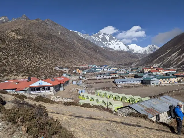
Dingboche offers essential lodging options for trekkers heading to Everest Base Camp. While facilities are basic due to the remote location, visitors will find comfortable teahouses and mountain lodges that provide warm beds, hot meals and all the basic amenities.
The village has several well-known hotels, including the popular Hotel Good Luck, renowned for its cleanliness and friendly owner, Kul Tamang. Another is Summit 4410m, which has cozy rooms with solar-powered charging stations.
For those seeking a quieter atmosphere, Peaceful Lodge provides a more relaxed stay away from the main trail. Most accommodations range from $3-20 per night, with prices often negotiable during off-peak seasons.
Dining in Dingboche is a mix of local and international dishes to fuel your trek. The staple dal bhat (lentils, rice, and vegetables) remains the most reliable meal, offering unlimited refills for hungry hikers.
Many lodges serve garlic soup, believed to help with altitude acclimatization, along with Sherpa stew, momos (dumplings), and even apple pie. While meat options are available, vegetarian dishes are generally safer at high altitudes.
All Dingboche teahouses provide communal dining areas heated by yak dung stoves, which is the perfect place to swap stories with fellow trekkers. Remember that WiFi and charging come at an extra cost, and hot showers may be limited.
During peak seasons (March to May and September to November), arriving early to secure accommodation is advisable as the village can get crowded.
Dingboche Monastery is the spiritual heart of this high-altitude Sherpa village. Visitors can observe morning prayer ceremonies and admire the intricate Buddhist thangka paintings in this sacred space. The monastery's peaceful atmosphere is a perfect retreat after trekking.
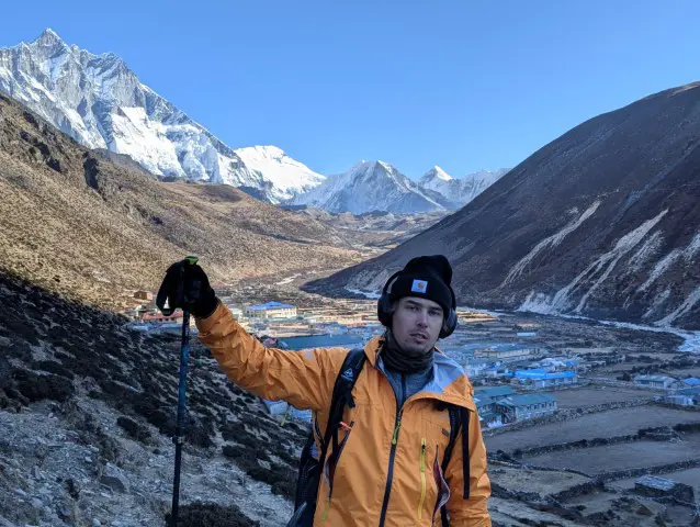
Dingboche, the scenic “Summer Valley” at 4,410 meters, offers trekkers breathtaking panoramic views of Lhotse, Island Peak, and Lobuche East. The towering Lhotse (8,516 m), the world’s fourth-highest peak, dominates the skyline with its massive south face, while the elegant Island Peak rises like a rocky island amidst glaciers to the east.
Adding to the spectacle, Lobuche East stands with its striking pyramid-shaped ridges, making Dingboche a perfect vantage point for enjoying some of the finest Himalayan scenery during the Everest Base Camp trek and a key acclimatization stop before heading higher.
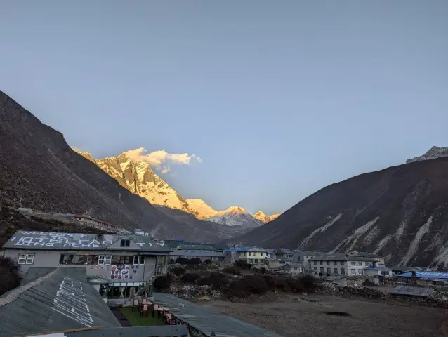
For the best views of Ama Dablam, head to the eastern edge of Dingboche at sunrise. The mountain's iconic pyramid shape appears to glow in the morning light, creating what many consider the most photogenic Himalayan vista on the Everest Base Camp trek.
The Imja River Walk can be an easy acclimatization hike for your group with stunning rewards. Follow the turquoise glacial waters past ancient mani stones and prayer flags to discover hidden viewpoints perfect for landscape photography.
This gentle 1 to 2 hour walk helps trekkers adjust to the altitude while offering panoramic mountain views.
Cultural explorers will appreciate Dingboche's traditional Sherpa landmarks, like:
Centuries-old mani walls carved with Tibetan Buddhist mantras
Historic stone farmhouses with distinctive wood trim
Rotating prayer wheels along the village pathways.
Nearby villages make excellent day trips from Dingboche.
Pheriche (1 hour): Visit the Himalayan Rescue Association clinic
Chhukung (2 hours): Gateway to Island Peak climbs
Pangboche (3 hours): Home to Khumbu's oldest monastery
Don't miss the Nangkartshang Peak hike (5,083m), which also has 360-degree views of Mount Everest, Lhotse and Makalu. This slightly challenging 4 to 5 hour roundtrip is considered one of the best acclimatization hikes in the region.
For a more cultural experience, observe local farmers tending to their high-altitude potato and barley fields. These are some of the highest-elevation agriculture activities in the world. The ancient stone-walled terraces demonstrate remarkable adaptation of the locals to mountain living over the yeears.
The best photography light is at dawn when Ama Dablam glows pink and at dusk when the Imja River reflects the surrounding peaks. Pack a good zoom lens to capture the details of these breathtaking landscapes.
Season | Avg. Daytime Temp (Hot Days) | Avg. Nighttime Temp (Cold Nights) | Avg. Daily Maximum | Avg. Daily Minimum |
Spring | 3°C | -18.7°C | -1.7°C | -12.7°C |
Summer | 10.7°C | -2.3°C | 7.7°C | 1°C |
Autumn | 5.7°C | -16°C | 1.7°C | -9.3°C |
Winter | -3°C | -28°C | -7.7°C | -20.7°C |
Note: (Meteoblue, 2025)
Dingboche experiences extreme alpine weather year-round. Winters (December–February) are bitterly cold, with temperatures plunging as low as -30°C, and even daytime highs remaining below freezing,making this season the least favorable for travel.
Spring (March–May) sees a gradual rise in temperatures, offering clearer skies and blooming landscapes despite chilly nights, making April to May ideal for trekking. Summer (June–August) brings the warmest conditions, with daytime highs reaching up to 12°C, but increased humidity and monsoon clouds may reduce mountain visibility.
Autumn (September–November) features crisp air, stable weather, and dry trails, especially in September and early October, although temperatures begin to drop steeply by November.
Month | Daytime Temperature | Nighttime Temperature | Mean Daily Maximum | Mean Daily Minimum |
March | 0°C (hot days) | -24°C (cold nights) | -5°C | -18°C |
April | 3°C (hot days) | -19°C (cold nights) | -2°C | -13°C |
May | 6°C (hot days) | -13°C (cold nights) | 2°C | -7°C |
Note: (Meteoblue, 2025)
Spring in Dingboche brings a gradual transition from extreme winter cold to more tolerable trekking conditions, though it remains chilly due to the village’s high altitude. In March, temperatures are harsh, with daytime highs around 0°C and nighttime lows plummeting to -24°C. April sees a slight improvement, with warmer days reaching 3°C and nights around -19°C.
By May, conditions become relatively milder, with daytime temperatures rising to 6°C and nighttime lows around -13°C. Despite the cold nights, the increasing warmth during the day and clearer skies make late April to May the most favorable time to visit in spring.
Month | Daytime Temperature | Nighttime Temperature | Mean Daily Maximum | Mean Daily Minimum |
June | 9°C (hot days) | -5°C (cold nights) | 6°C | -1°C |
July | 11°C (hot days) | -1°C (cold nights) | 8°C | 2°C |
August | 12°C (hot days) | -1°C (cold nights) | 9°C | 2°C |
Note: (Meteoblue, 2025)
Summer in Dingboche, from June to August, offers the warmest temperatures of the year, though conditions remain cool due to the high elevation. June starts off with daytime highs around 9°C and nighttime lows near -5°C, with a mean daily range between 6°C and -1°C. July and August see slightly warmer days, reaching up to 12°C, while nights hover just below or around freezing.
The average maximums rise to 8–9°C, and minimums settle at 2°C. Despite the warmth, summer also brings increased humidity and chances of rain due to the monsoon, though the temperatures are ideal for those who prefer milder trekking conditions.
Month | Daytime Temperature | Nighttime Temperature | Mean Daily Maximum | Mean Daily Minimum |
September | 10°C (hot days) | -6°C (cold nights) | 7°C | -1°C |
October | 6°C (hot days) | -19°C (cold nights) | 1°C | -10°C |
November | 1°C (hot days) | -23°C (cold nights) | -3°C | -17°C |
Note: (Meteoblue, 2025)
Autumn in Dingboche begins with relatively mild conditions in September, featuring daytime highs of 10°C and nighttime lows around -6°C. As the season progresses, temperatures drop significantly. October sees daytime temperatures fall to 6°C and nights to a sharp -19°C, with a mean daily minimum of -10°C.
By November, the cold intensifies, with days barely reaching 1°C and nights plunging to -23°C. The mean daily maximum is -3°C, and the minimum around -17°C. Despite the increasing chill, autumn is favored for trekking due to stable weather, dry trails, and crisp, clear mountain views, especially in September and early October.
Month | Daytime Temperature | Nighttime Temperature | Mean Daily Maximum | Mean Daily Minimum |
December | -1°C (hot days) | -27°C (cold nights) | -6°C | -19°C |
January | -5°C (hot days) | -30°C (cold nights) | -9°C | -22°C |
February | -3°C (hot days) | -27°C (cold nights) | -8°C | -21°C |
Note: (Meteoblue, 2025)
Winter in Dingboche is harsh and extremely cold, with temperatures dropping well below freezing throughout the season. December starts off with daytime highs at just -1°C and frigid nights dipping to -27°C. January is the coldest month, with daytime temperatures falling to -5°C and nights reaching a bone-chilling -30°C.
February remains similarly cold, averaging -3°C during the day and -27°C at night. Mean daily maximums range between -6°C and -9°C, while minimums remain around -19°C to -22°C. The intense cold, combined with strong winds and potential snowfall, makes winter the least favorable season for visiting Dingboche.
The image below showcases a traditional Buddhist chorten (stupa) in Dingboche, a serene village in Nepal’s Everest region. Chortens are sacred monuments that symbolize enlightenment, peace, and protection.
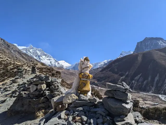
Often adorned with prayer flags and wrapped in white scarves, they serve as spiritual markers for trekkers and locals alike. These chortens are strategically placed along trails and villages to bless travelers, ward off negative energies, and honor Buddha’s teachings.
The surrounding Himalayan landscape, including views of Ama Dablam and Lhotse, enhances the spiritual ambiance, making Dingboche not only a trekking hub but also a site of profound cultural and religious significance.
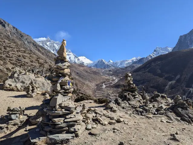
While trekking in Dingboche, you’ll come across beautifully stacked stone cairns often draped with colorful Tibetan prayer flags. These cairns, known locally as "chortens" or "memorial cairns," are more than just piles of rocks – they hold deep cultural and spiritual significance in the Sherpa and Buddhist traditions.
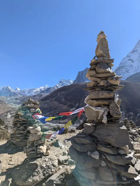
What They Symbolize:
Spiritual Protection: Cairns are believed to bless travelers with safe passage through the high mountains.
Offerings to the Divine: Each stone placed symbolizes prayers, gratitude, and respect to the mountains and deities.
Memorials: Some cairns honor climbers and Sherpas who lost their lives in the Himalayas.
Guidance: In remote trails, cairns act as natural signposts, guiding trekkers along the correct path.
The colorful flags (blue, white, red, green, yellow) represent the five elements: sky, air, fire, water, and earth. As the wind blows, it carries blessings, peace, and goodwill across the valleys.
Visiting these cairns in Dingboche is not only a spiritual experience but also a chance to reflect on the sacred connection between nature, culture, and mountaineering traditions in Nepal.
A fascinating tradition of residents at Dingboche is that they leave the village for a month during mid-July to mid-August (the Nepali month of Shrawan) to go to nearby villages. This is said to be done for the well-being of the animals the locals rear.
According to local legends, the residents of Dingboche shouldn’t cook food in their village during this month. So, they go to nearby villages for their meals the whole month.
The tradition was followed more strictly during earlier times. Now, although some villagers, especially business owners do follow it, many choose to disregard it and stay and eat at the village as usual.
Meteoblue. (2025). Climate & weather data for Dinboche. Meteoblue. https://www.meteoblue.com/en/weather/historyclimate/climatemodelled/di%e1%b9%85boche_nepal_1283437
Dingboche is located in the Imja Valley of Nepal's Khumbu region within Sagarmatha National Park. The village sits along the Everest Base Camp trekking route between Tengboche and Lobuche.
Dingboche is situated at an elevation of 4,410 meters (14,470 feet) above sea level, making it one of the highest permanent settlements on the Everest Base Camp Trek.
Yes. Dingboche is considered a standard acclimatization stop on the Everest Base Camp itinerary, and most trekking agencies schedule at least one full acclimatization day there.
At 4,410 meters, oxygen availability is approximately 40% lower than at sea level, which is why acclimatization is essential before trekking higher.
Check out recent travel trends and news by Trek me Nepal


More Reasons Why Travellers Trust Us


 | Best Himalayan Adventure Companies")
Bipin Thapa Magar
Guide of the Year | Operations Manager & Chief Planner | Trek Me NepalBipin Thapa Magar is a highly experienced trekking and expedition professional with over 20 years in Nepal’s adventure tourism industry. He began his journey in 2004 as a porter and gradually advanced... Read More